
-
 Gyroscope navigation utilizes the accurate orientation information from gyroscopes. Alongside components like the machine's moving wheels and collision mechanisms, it captures the path the machine covers during its operation. Using this mapped data, the system performs functions like localization, navigation, and motion control.
 -
 In LiDar SLAM navigation, the LiDar rotates 360 degrees to scan the flat space within a 10-meter radius, creating a flat map.This map, along with data gathered from various sensors such as collision sensors and wall-following sensors, are all utilized in autonomous tasks such as localization, navigation, and path planning through SLAM algorithms.
 -
 Visual navigation employs cameras to capture images of the surrounding environment. Through image filtering and computation, it determines the device's position, recognizes paths, and makes navigation decisions. Operating passively, this method is characterized by simplicity, low cost, and widespread applicability. Its primary features include autonomy and real-time capability, requiring no external device reliance. Visual navigation derives navigation details solely through the computation of stored system and environmental information.
 -
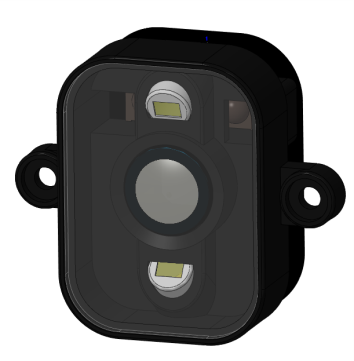
 The 3D Time-of-Flight (3DTOF) technology, integrated with 3D mapping and obstacle avoidance capabilities, can be equipped with LiDar/vision SLAM. This enables applications such as path planning, obstacle avoidance, and identification of hazardous obstacles and etc.
 -
 The line laser obstacle avoidance and wall following solution can achieve real-time avoidance of low obstacles, ensuring seamless machine maneuver.Additionally, it has the features as: small detection blind zone, intelligent obstacle avoidance, anti-jamming and can operate during nighttime.